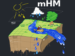
The mHM is a spatial hydrologic model that models hydrologic processes such as infiltration and surface runoff, evapotranspiration, groundwater formation, soil moisture, and flood routing developed by UFZ. The main feature of mHM is the approach to estimate parameters at the target resolution based on high resolution physiographic land surface descriptors (e.g., DEM, slope, aspect, root depth based on land cover class or plant functional types, LAI, soil texture, geological formation type) via multiscale parameter regionalization (MPR).
The software is GPL-3.0-or-later (see license).
--> Look in the natESM system table for more information about this optional component.
More information, publications and members of the team about mHM here and in the Reasearch Software Directory of HIFIS.
If you want to get started, the software is available on GitLab. The latest documentation is filed here, which includes also a "Getting started" section.